ACQUISTION PROCEDURE OF FREE GEOSPATIAL DATA FROM BHUVAN , NRSC , USGS , COPERNICUS SENTINEL HUB ESA
BHUVAN
Indian Web based Geoplatform of ISRO,Replica Of Google.
Bhuvan, (lit: Earth), is an Indian web based utility which allows users to explore a set of map based content prepared by Indian Space Research Organisation. The content which the utility serves is mostly restricted to Indian boundaries and is offered in 4 regional languages. The content includes thematic maps related to disasters, agriculture, water resources, land cover and also processed satellite data of ISRO. Bhuvan is known for its association with various sections of Government of India to enable the use of Geospatial technology. Bhuvan has since its inception enabled Indian government to host public geospatial data as Information layers for visualisation and public consumption. Examples of the types of geospatial layers include Toll Information System for National Highways Authority of India , Islands information System for MHA, Cultural heritage sites for Ministry of culture etc. The information for the platform is obtained from the government of India sources or through Crowdsourcing.
ISRO launched the Beta version of its web-based GIS tool, Bhuvan, on August 12, 2009. Bhuvan offers detailed imagery of Indian locations compared to other Virtual Globe Software, with spatial resolutions ranging up to 1 metre. At present 177 cities High resolution datasets are available,while the other part of the country is covered by 2.5m resolution imagery. The images available do not include any military installations in India, due to security concerns.The National Remote Sensing Agency played an important role in the development of this product. ISRO has used data provided by satellites including Resourcesat-1, Cartosat-1 and Cartosat-2 to get the best possible imagery of India
Keynotes Of BHUVAN Webportal
20 TB data • 69K Registered Users • 1 M unique visitors • 125 K Subscribers • 570K free downloads • Crowdsourcing ~ 4M • Navigation Map POI ~ 5M
Functions
Bhuvan a Geo-Platform of ISRO,was launched in 2009 showcasing Multi sensor, Multi-platform and Multi temporal Satellite Imagery from 56m to 1m spatial resolution for the entire country. It has rich thematic data in the form of Land Use/Land Cover, Waste Land, Geomorphology, Urban Land Use, Lineaments, Water Bodies, etc. Apart from these thematic data, Bhuvan also provides rich & diverse data on Hydrological Boundaries, Climate and Environment, Disaster, Forestry, Tourism, Water, Urban, Agriculture, etc. In addition to these, Bhuvan also caters to the administrative and infrastructure layers, from the National level to that of the street level. Apart from high resolution data visualization, Bhuvan also provides data through download services and Maps as OGC Services. Bhuvan provides support to Disaster Services by making available the near real time data, pre and post disaster imagery and various spatial information, which are helpful during disaster events in the country.
- In the recent COVID-19 pandemic situation, Bhuvan has extended support to Government by providing Geospatial solutions on Bhuvan. Bhuvan brought out now the various mobile applications and web based utilities helping decision makers and citizens to fight against COVID-19.
Bhuvan, as a platform, has developed applications supporting decision making, monitoring and evaluation of various domain specific applications in collaboration with various Ministries, Central Government and State Government departments. As of today, various Central and State Government departments under more than 24 Ministries are supported with 182 applications and 30 State Portalsthrough Bhuvan. As the national imperative applications are done jointly with Ministries involved in managing natural resources in the country from National to local level, they have become part of Bhuvan team.
- Special Services Of BHUVAN to its users are
Map Services State Portals Applications Visualization and Free Download Crowd sourcing
Significance
Scientists, academicians, policy makers and general public can leverage this integration of vast amounts of geospatial data in an easy-to-use multi-lingual interface without any additional resources
The tool's visual immediacy could prove enormously beneficial, for example, for a survey of various geological structures in a region Individually, students can use Bhuvan to know and examine places they are studying.
Also allows them to create and share personal resources like data sharing Bhuvan lets users to download specific satellite data and products, and also encourages users to revisit and explore availability of new datasets
1. We will have to go to Google and type Bhuvan (Indian Portal of ISRO) and click
enter: bhuvan.nrsc.gov.in
2. A page will open, you will click on open data archive
3. You will need to Log in first.
.
How to download LISS 3 Resourcesat , LULC,NDVI data from BHUVAN Portal We will Have Discuss in the next journal.
NATIONAL REMOTE SENSING CENTRE
National Remote Sensing Centre (NRSC) at Hyderabad is responsible for remote sensing satellite data acquisition and processing, data dissemination, aerial remote sensing and decision support for disaster management. NRSC has a data reception station at Shadnagar near Hyderabad for acquiring data from Indian remote sensing satellites as well as others.
NRSC Ground station at Shadnagar acquires Earth Observation data from Indian remote-sensing satellites as well as from different foreign satellites. NRSC is also engaged in executing remote sensing application projects in collaboration with the users. The Aerial Services and Digital Mapping (ASDM) Area provides end-to-end Aerial Remote Sensing services and value-added solutions for various large scale applications like aerial photography and digital mapping, infrastructure planning, scanner surveys, aeromagnetic surveys, large scale base map, topographic and cadastral level mapping, etc.
National Remote Sensing Centre (NRSC) has the mandate for establishment of ground stations for receiving satellite data, generation of data products, dissemination to the users, development of techniques for remote sensing applications including disaster management support, geospatial services for good governance and capacity building for professionals, faculty and students.
UNITED STATES GEOLOGICAL SURVEY
The United States Geological Survey (USGS, formerly simply Geological Survey) is a scientific agency or web portal maintained by of the United States Of America for providing free download (civil data)satellite data are captured by the LANDSAT MISSIONS,Sentinel,ISRO RESOURCESAT,EO-1,Commercial satellite like IKONOS 2,Orb View 3etc.The scientists of the USGS study the landsacpe of the United States,its natural hazards that threaten.The organization's work spans the disciplines of geography,Gis,Gology,Botany,Biology and hydrology.The USGS is a fact-finding research organization with no regulatory responsibility.
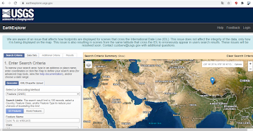
Earth Explorer - The USGS Earth Explorer is a similar tool to the USGS Global Visualization Viewer (GloVis) in that users search catalogs of multiple free satellite and aerial imagery. The USGS Earth Explorer data portal is one stop shop for obtaining geo-spatial datasets from extensive collections,resolutions.Users can navigate via interactive map or text search to obtain Landsat satellite imagery, Radar data,AVHRR data, UAS data, digital line graphs, digital elevation model data, aerial photos, Sentinel satellite data, some commercial satellite imagery including IKONOS and OrbView3, land cover data, digital map data from the National Map, and many other datasets.Users also can search here by exact location via the interactive map or input specific coordinates to view what data types are available.
The USGS Earth Explorer interface uses Google Maps.Google street view is also enabled, where you can drop a marker and get a real view of the location.First, you’ll have to create an account with USGS. In the top-right corner, click the REGISTER button.
The USGS Earth Explorer gives some extra capabilities to its users :
- Downloading data over chronological timelines.
- Specifying a wide range of criteria for searches.
- Choosing from a long list of satellite and aerial imagery.
How to download USGS Landsat 8,DEM,Elevation dat we Will have discuss it later.
COPERNICUS OPEN ACCESS HUB - ESA
Copernicus is the Europian Union's Earth observation programme coordinated and managed by the European Missions in partnership with the European Space Agency (ESA),The E.U Member States and E.U Agencies.The Copernicus Open Access Hub (previously also known as Sentinels Scientific Data Hub) provides complete, free and open access to Sentinel-1, Sentinel-2, Sentinel-3 and Sentinel-5P user products, starting from the In-Orbit Commissioning Review (IOCR).
Aim & Objective-
Copernicus open access scihub aims at achieving a global, continuous, autonomous, high quality, wide range Earth observation capacity.The objective of it is to use vast amount of global data from satellites and from ground-based,airborne and seaborne measurement systems to produce timely and quality information, services and knowledge, and to provide autonomous and independent access to information in the domains of environment and security on a global level in order to help service providers, public authorities and other international organizations improve the quality of data.
Sentinels Data Voucher
- .The Sentinel-1 data offer for the Open Access Hub consists of -Level-0, Level-1 user products-StriP Map (SM).Extra width Swath(SW),Level-2 user products wAVE (wv),Extra WiDth Swath (EW)
- The Sentinel-2 data offer for the Open Access Hub will consist of Level-1C and Level-2A user products.
- The Sentinel-5P data offer for the Open Access Hub will consist of Level-1B and Level-2 user products for the TROPOMI instrument
Sentinel Data are also available via the Copernicus Data and Information Access Services (DIAS) through several platforms.
Anyone can register online via self-registration. The self-registration process is automatic and immediate.Registration grants access rights for searching and downloading Sentinels products. Sentinels products are available at no cost for anybody.How to download Sentinel 1,2,3,5p data step by steps willbe discussed at later.
Here I am Sudip Dey have try to Prepare a Quick Remembering Quiz on Aquisition of free geospatial data collection, Just Click on the Goggle form icon below below
REFERENCE
https://bhuvan.nrsc.gov.in/bhuvan_links.php
http://www.isro.gov.in/httpsabout-isro/national-remote-sensing-centre-nrsc
https://www.nrsc.gov.in/
https://bhuvan.nrsc.gov.in/bhuvan_links.php
https://www.usgs.gov/
https://en.wikipedia.org/wiki/United_States_Geological_Survey
https://scihub.copernicus.eu/userguide/
https://en.wikipedia.org/wiki/Copernicus_Programme


5 Comments
In the next Blog Sudip Will Try to Prepare How To Download Data From these web portal with a Brief Handout Presentation.If Anyone Have Any suggestions for improvement these blog ,they can sahre their Valuable Comments Or They may have also be shared What's Type of Journal they need to.
ReplyDeleteYeah Sure
DeleteGood Thank You Sudip
ReplyDeleteGood 👍
DeleteThanks
Delete